Part Four
The Limits to Progress: The Auckland Harbour Bridge, 1959-1969
by Nathan McLeay*
In the eyes of many Aucklanders, the bridge, Auckland’s soaring highway in the sky stood as proud testament to the city’s progress and to the vision and tenacity of its officials. Not only was the bridge a sign of how far Auckland had come, but also where Auckland was going.
The North Shore, which for so long had sat tantalisingly out of reach, isolated by the unattractive proposition of either a ride on the Devonport Steam Ferry Company’s primitive coal-fired vessels or a 50 kilometre, several hour drive via Riverhead, was suddenly opened up to easy access and to development. The North Shore’s potential could finally be realised, and it had the bridge to thank.
Unsurprisingly, not all residing on the North Shore were grateful. Before work on the bridge had even begun, a number of shore-siders had voiced concerns that, by opening the North Shore up for development, a bridge would strip their community of the rustic quality that its partial seclusion offered. In a poetic letter submitted to the New Zealand Herald in 1953, one North Shore resident made their feelings abundantly clear:
“When the shrill inevitable death knell of saws shatters the silence and solace of the pines, we shall go quietly. When the creaking and demolishing begins of homes whose rooms hold echoes of all our laughter and all our tears, when the scream of pneumatic drills is the daily companion of sunlight and the sea-birds hover in dismay over the unnatural scene, we shall be seeking vainly some other haven within our moderate means where a 15 minute ferry trip transports one to the heart of the city, where lingers yet the out-of-this-world tranquillity, the sunlight and harmony that has made radiant our children’s youth and where middle aged backs may bend to plot and plant and grow again some other garden or discover some new Eden of escape.”[1]
These fears of demolition and lost tranquillity were realised with the opening of the harbour bridge. The bridge was a major catalyst for the development of the North Shore. The price of land—coastal land especially—soared, and beachside baches were torn down and replaced by town houses, flats, and larger, multi-storey dwellings. Further inland, roads were widened, the motorway was extended, and housing subdivisions, shopping centres, and commercial and industrial buildings sprang up.[2]
Particularly affected by this new development was a flourishing literary community on the North Shore. Taken by the area’s relaxed pace of life, cheap bach accommodation, and close proximity to, but detachment from, the central city, writers such as Frank Sargeson, A.R.D. Fairburn, Janet Frame, and Alan Curnow had in the mid-twentieth century established the North Shore as a literary hub. Poet, novelist, and author of short stories Kevin Ireland claimed that the Shore was loved by writers for its “stunning position on the Waitemata Harbour, its superb hills, sea and beaches, its community of fellow writers and artists, and its isolation from, yet proximity to, Auckland.”[3] In a similar vein, the poet and novelist C.K. Stead described the North Shore before opening of the harbour bridge as being “quiet, lovely and not overpopulated, a beach suburb close to town, but removed from it.”[4]

Looking east over Glenfield toward Lake Pukupe, North Shore, 1955. Whites Aviation, “Ariel view of Glenfield,” black and white photograph, Auckland Libraries Heritage Collections T5316.
With the arrival of the harbour bridge, the North Shore’s days of quiet seclusion were numbered. To its many creatives, the North Shore had been invaded from across the bridge; it was no longer their place, but a place that they were increasingly being priced out of, a place that, with every new road and building, was becoming increasingly unfamiliar. Works by some North Shore writers began to reflect their dismay at the effect that “progress” was having on their community. Janet Frame’s 1964 poem “The Road to Takapuna” dealt with human imposition on nature: “When they reclaimed the land, the sea made little fuss about possession, or such legal niceties as who was first owner.”[5] And in his 1967 poem “Building Programme,” Kendrick Smithyman lamented that “they are changing the way of my city. The Skyline is not what it was, nor are we.”[6]
Symbolic of the bridge’s effect on the North Shore is short story writer and novelist Frank Sargeson’s bach at 14 Esmonde Road, Takapuna, where he had resided since 1931. There he wrote most of his works, entertained writers and artists of all kinds, and took in “strays,” including Janet Frame, who between 1954 and 1956 boarded in an army hut at the rear of the house while she wrote her first novel, Owls Do Cry.[7] With the construction of the bridge, Esmonde Road, the quiet thoroughfare along which Sargeson’s tiny fibrolite bach sat, was converted into a major feeder-road to the Auckland Northern Motorway. Sargeson was appalled, though he would eventually get his own back. During road expansions in the early 2000s, allowance had to be diverted to avoid his ashes, which were buried in the front garden of his former home. This re-route was known to traffic engineers as “the Sargeson Swerve.”[8]
With the rapid urbanisation of the North Shore, and the continuing post-war proliferation of the private motor car, another of the bridge’s shortcomings soon became readily apparent—it simply wasn’t large enough to accommodate Auckland’s ever-increasing traffic. Virtually from day one, traffic had exceeded expectations, and the loss of the fifth and sixth traffic lanes proposed by the 1946 commission meant that the bridge authority could not use tidal flow traffic management to control demand. On August 17, 1959, the bridge saw the crossing of its millionth vehicle, and it continued to rack up new milestones with increasing regularity. In June 1960, after slightly over one year in operation, five million vehicles had crossed, leading Sir John Allum to comment that “we are getting quite blasé about our millions.” The crossing of the 10 millionth vehicle was marked on April 23, 1961 and the 20 millionth on November 7, 1962.[9]

The Auckland Harbour Bridge, flooded with traffic. This photograph was taken shortly after the bridge opened in 1959. Olaf Petersen, “Traffic on the Auckland Harbour Bridge,” Auckland War Memorial Museum – Tamaki Paenga, Print, PH-1988-9.
In early 1962, Allum urged the Auckland Regional Planning Authority to begin planning for a second harbour crossing, warning that the bridge would reach its carrying capacity by 1969, and that its saturation point would soon follow. It was decided in July, 1964, however, that the looming threat of standstill across the bridge would be averted not by a second crossing, but instead by adding to the original structure. The Auckland Harbour Bridge Authority recommended the construction of an additional two-lane carriageway on either side of the existing structure and, after receiving government backing, put a contract out to tender. In 1966 a tender was approved from Japanese firm Ishikawajima–Harima Heavy Industries, who planned to ‘clip’ prefabricated extensions to the side of the bridge via floating cranes—hence the extensions’ nickname, the “Nippon clip-ons.”[10] The four clip-on lanes opened in 1969, at a cost far beyond what would have been the case for any bridge built ten years earlier with a realistic view of probable demand.[11]
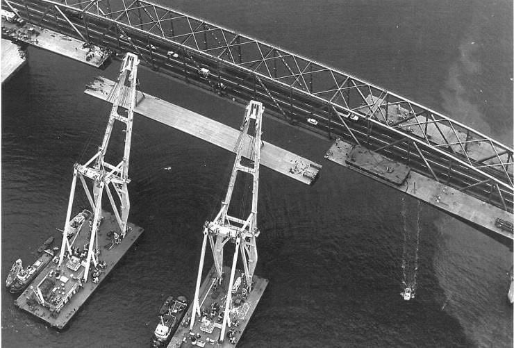
Floating cranes manoeuvre a centre section of the ‘clip-on’ additions into place, September 1968. Auckland Harbour Bridge Extensions, compiled by Albert Chan, Auckland, 1993, p.17.
The Auckland Harbour Bridge offers thus offers a useful reminder of the perils of cost-cutting and short-term planning. Built with provisions only for cars, it was quickly realised that those provisions simply weren’t enough, necessitating the construction of additional lanes. Similarly, new construction has very recently been approved to address the bridge’s lack of accommodation for cyclists or pedestrians. Cycling and walking advocates have long lobbied the government for access on the bridge, but only found success late last year, as the government agreed to fully fund the $67 million ‘Skypath’ project, expected to be completed by 2021 (although this scheme has recently been thrown in doubt by a row over design rights).[12] And, as far as trans-harbour rail is concerned, one is left only to imagine what might have been. With the clip-ons and (fingers crossed) the Skypath, the initial failures of the Auckland Harbour Bridge have been addressed as best as could be hoped—albeit at a significant cost. It is crucial that those failures now are learned from.
*Nathan McLeay was awarded a 2019 Summer Scholarship at The University of Auckland out of a highly competitive field and his award was funded by a Jonathan and Mary Mason Summer Scholarship in Auckland History. His research project explored the history of the Auckland Harbour Bridge
[1] Renée Lang, Auckland Harbour Bridge: 50 Years of a City Icon, Auckland, 2009, pp.10-11.
[2] David Verran, The North Shore: An Illustrated History, Auckland, 2010, pp.205-211.
[3] Graeme Lay, North Shore Literary Walks, Auckland, 2002, p3.
[4] ibid., p.2.
[5] Janet Frame, “The Road to Takapuna,” Mate, 12, 1964.
[6] Kendrick Smithyman, ‘Building Programme’, Landfall, 21, 1967.
[7] Auckland Council, North Shore Heratige – Thematic Review Report, Auckland, 2011, p.241.
[8] Devonport Flagstaff, “Scenes from a writer’s life transported to Devonport,” 22 September, 2017, p.46.
[9] Lang, p.56-61.
[10] New Zealand Herald, ‘Rise of the Nippon Clip-on’, November 21, 1992.
[11] Bush, From Survival to Revival, pp.167-8.
[12] “Campaign for cycleway under harbour bridge,” North Shore Times Advertiser, July 6, 1976, p.5; http://www.skypath.org.nz/.