Part Two
Parnell: A Suburb of Contrasts
Part One
Parnell: The Patchwork Suburb
Part Three
Gentrification in Parnell
Part Four
Living in Parnell
“The Parnell district is destined to become one of the city’s most important multi-family residential areas, and will become heavily populated. The district is now substantially built up, and very little, if any, area is now available for such development.” – Mr A. J. Dickinson, Parks Committee, October 1945 [1]
“Looking to the future, Parnell faces both challenges (such as from ongoing port activities) and opportunities to capitalise on its unique and excellent attributes and ensure it remains a desirable place to work, live, play, and visit, as well as a prosperous place in which to do business.” – The Parnell Plan, June 2019 [2]
Located on the periphery of Auckland’s CBD, Parnell has an extensive history as one of the city’s oldest suburbs. The area has a reputation of affluence and prestige – in part due to this long history, but also to the prevalence of boutique stores, expensive restaurants, and beautiful scenery. One could be forgiven for assuming that Parnell has always been like this. However, underneath this esteemed veneer, a different story becomes clear. Rather than having a history defined by wealth and prosperity, the story of Parnell is instead characterised by contrasts. Throughout the twentieth century, there emerges two different Parnells: ‘upper’, and ‘lower’.
Parnell was vital to the early development of Auckland. Its proximity to the central city, as well as the waterfront, meant that Parnell functioned as a housing and industrial hub for early Auckland. Parnell Road was a major thoroughfare, linking the city with further-out suburbs such as Remuera and Newmarket. There was also a tramline running along this road which supplied accessible transport for those living throughout the south-east region of the city. The area itself was relatively built-up. The 1911 census, the last one taken before Parnell was incorporated into Auckland City, indicates that the full population of Parnell Borough were living in ‘Houses of Brick, Stone, Wood, Iron, or Lath and-Plaster’.[3] Average weekly rent varied between 5 shillings 10 pence for a two-room dwelling all the way to 1 pound 18 shillings and 11 pence for a 10 plus room home. By using the Reserve Bank of New Zealand’s inflation calculator, we can figure out a rough equivalent value.[4] In terms of 2019 dollars, a two-room dwelling would cost $50 per week, and a 10 plus room dwelling would cost approximately $335 per week. This is an incredibly rough measure, but it helps illustrate the changing costs of living in Auckland. For some comparison, a quick look for rental property in Parnell on TradeMe returned weekly rents of $400 or more, no matter what size dwelling one looks for. This is a stark contrast to 1911.
By the mid-twentieth century, this grand old suburb was in disarray. The major issues of the early twentieth century – the Great Depression, a housing crisis, and the Second World War – had impacted the entirety of the country, and Parnell did not escape this. In contrast to modern images of Parnell as a prosperous suburb, in the 1940s the word ‘slum’ was often used by politicians and residents to describe the area.[5] It is important to recognise that this would not have necessarily described the entire suburb. While it seems that parts of Parnell were dominated by working-class families, it was actually an area of major wealth disparity. Many of the larger homes throughout Parnell today can give off the impression of a uniformly-affluent suburb, and do not give one the impression of a ‘slum’. Indeed, many of these homes would not have sat in the area politicians were calling the slums, but instead in ‘upper Parnell’. It is likely that when politicians spoke of the Parnell slums, they were referring to ‘lower Parnell’. One resident who grew up in this period noted that this could be broadly imagined as anything past Aorere Street up to the waterfront, Auckland City, and the Domain. Further down Parnell Road is where ‘upper Parnell’ existed.[6]
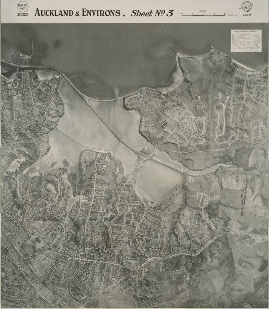
Aerial Photo: “Auckland and environs, Sheet no. 3”, 1940. On the left-hand side of this image, one can make out the remarkably well-developed Parnell, in comparison to the in-progress construction of Orakei. Parnell’s development made it a less attractive target for the state-housing initiatives of the post-war period. Auckland Libraries Heritage Collections Map 6226, Auckland.
One of the more infamous examples of ‘lower Parnell’ is the building known as Avoca House, or as it was more popularly referred to, ‘Paddy’s Puzzle’. This building was an apartment block on the corner of St Georges Bay and Cleveland Road. A 4-storey, ferroconcrete maze, with stairs which led to nowhere and plumbing which connected apartments and rooms in all sorts of haphazard ways, Paddy’s Puzzle was a prime example of what politicians meant when they called Parnell a slum. During the Great Depression, the building was leant to the Presbyterian Social Service Association to provide cheap rooms for those requiring assistance.[7] During the Second World War, the building continued to be a source of housing for those on a lower income. Ian Kidman, who lived there with his grandmother, recalls that residents in the building were mainly Māori women whose husbands were serving overseas.[8] Many of the residents either worked in nearby industry – Ian recalls that a number of the women worked in the nearby Nestle factory – or had alternative employment. Prostitution, it seemed, was also a staple form of income for those living in the building, attracting a number of American soldiers to the region.[9] After the war, Paddy’s Puzzle continued to be a source of low-income housing, predominantly inhabited by Māori and Pasifika families. This provides a stark contrast to the 1911 census of Parnell’s population, which presented a picture of a remarkably homogenous suburb dominated by Europeans.
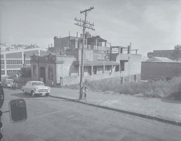
Photo: Avoca House, also known as Paddy’s Puzzle, 1961. Auckland Libraries Heritage Collections 580-5352, Auckland.
Hulme Court, today a Parnell landmark, showcases a different story. The historic home at 350 Parnell Road was originally built in 1843 and was inhabited by a prominent Auckland merchant and later prime minister of New Zealand, Frederick Whitaker. In 1941, Hulme Court became the residence of the Clark family, immigrants from the slums of Glasgow. In the Clarks we see evidence that the area must have been affordable to new migrants: Mr Clark was invalid, after spending some time as a coalminer in Scotland.[10] However, the once-stately home had seen significant wear-and-tear by this point. Helen Clark’s grandson Patrick Maguire remembers the house being ‘downtrodden’, and ‘old, but not flash’ during his visits there in the 1950s and 1960s.[11] The home underwent modifications while the Clarks lived there, at one point serving not just as a house but also a panel-beating and paint shop! This helps to illustrate the point that Parnell, an area often associated with ideas of wealth, did not necessarily maintain this trajectory in its own history. Homes which were initially linked with New Zealand’s middle or upper classes became locations for those on a lower income to live, while those who could afford to move elsewhere did so.
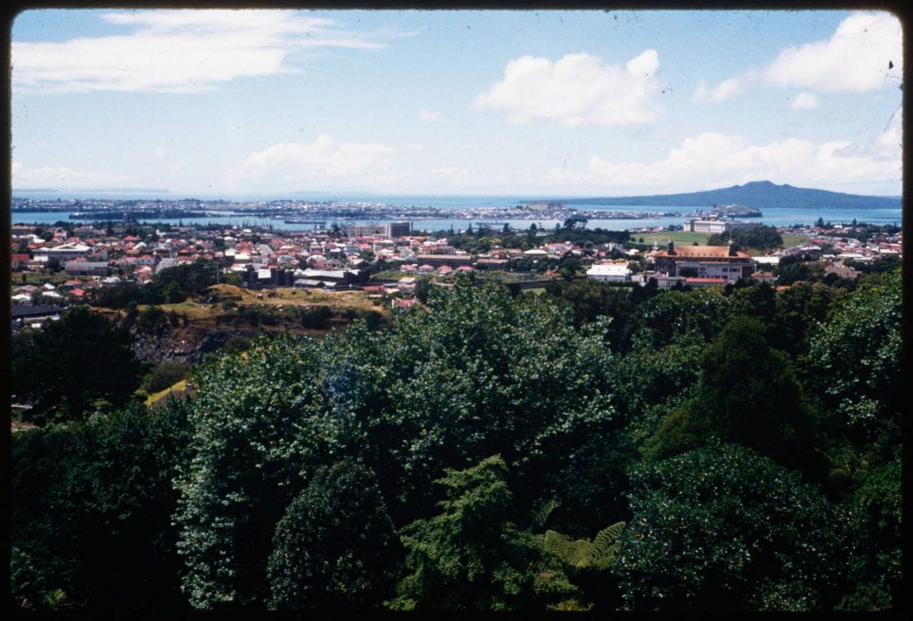
Photo: View from Parnell Rise, 1953. Auckland Libraries Heritage Collections 998-48, Auckland.
This trend would soon reverse. Over the course of the 1960s and 1970s, Parnell would undergo the process of gentrification, and in doing so force out some of its lower income residents. At the same time, however, Parnell’s gentrification would help maintain some of the suburb’s historic character. In my next article, I examine how Parnell changed over the following two decades, and how processes like gentrification impacted the ‘suburb of contrasts’.
[1]“Civic Affairs: Town Planning, The Future of Parnell”, New Zealand Herald, 12 October 1945, p.7.
[2]Auckland Council, The Parnell Plan: A 30-Year Plan for Auckland’s First Suburb, 2019, p. 11.
[3]New Zealand Government, 1911 Census Results, accessed via StatsNZ, https://www3.stats.govt.nz/historic_publications/1911-census/1911-results-census.html.
[4]To access the Reserve Bank’s inflation calculator, head to: https://www.rbnz.govt.nz/monetary-policy/inflation-calculator
[5]“Housing Problem: Position Deteriorating, Urgent Need of Relief”, New Zealand Herald, 26 April 1945, p. 6; “Correspondents’ Views: Cathedral”, Auckland Star, October 14, 1941, p. 6.
[6]David Grace, ‘Our House in Aorere Street: Memories of Parnell in the 1930s’, Parnell Heritage Journal, 2, 2012, p. 26.
[7]Joanna Boileau, ‘Paddy’s Puzzle’, Parnell Heritage Journal, 4, 2014, p. 23.
[8]Boileau, ‘Paddy’s Puzzle’, p. 24,
[9]Boileau, ‘Paddy’s Puzzle’, p. 23; Shelagh Coop and Fleur Denning, 2010, Oral History Recording with Peter McKay, Parnell Heritage Inc., PHOH2010/002.
[10]Jane & Antony Matthews, ‘Hulme Court: The Conservation of a Parnell Landmark’, Parnell Heritage Journal, 3, 2013, p. 23.
[11]Jane & Antony Matthews, ‘Hulme Court: The Conservation of a Parnell Landmark’, p. 23.