Part Three
How Auckland Ditched Rail for Roads and Rubber Tyres:
The tube
Part One
The good old trams
Part Two
Trams out; trolleybuses in
Part Four
Motorway mania
Part Five
Conclusions
by Sam Turner-O’Keeffe*
So, we have seen in the previous two articles that the decade after World War Two was crucial to Auckland’s history. By replacing its trams with trolleybuses, the city changed its character forever. Yet this development did not occur alone: during the post-war period, Auckland chose to neglect rail in favour of roads and rubber tyres twice. This second decision was markedly different. Firstly, it concerned not just the reshaping of Auckland’s existing transport infrastructure, but also proposals to completely expand it. Secondly, the big decision facing Auckland this time specifically pitted railways against motorways designed for the carriage of the private motor vehicle. But why did Auckland’s leaders wish to completely expand its transport infrastructure – and in pursuit of that end, why did the city force itself to choose between railways and roads? In attempting to answer these questions, the best place to start is with the looming threat of congestion.
A congested city
While the end of World War Two brought eagerly awaited peacetime for Auckland, it also revealed a growing problem. By 1945 Auckland boasted a motor vehicle ownership rate of 170 vehicles between every 1,000 people. This was a similar figure to the national rate of 164 motor vehicles per 1,000 in 1939. (Note that the wartime period kept these statistics relatively stable.) When compared to today’s figures – in 2017 Aucklanders owned about 740 motor vehicles per 1,000 people – this might seem low. However, it pays to recognise that at the time these figures were almost twice Australia’s motor vehicle ownership rate, and roughly three times that of Great Britain. Only the United States, at 221 motor vehicles per 1,000, boasted a higher rate of motor vehicle ownership. Why Aucklanders specifically liked their vehicles so much is a complex question; one possible answer is that the city’s sprawling geography proved very conducive to motor vehicle use, as workers and shoppers were required to travel long distances on a daily basis. Regardless, what is clear is that at the time, Aucklanders (and New Zealanders) owned a lot of cars relative to their population.
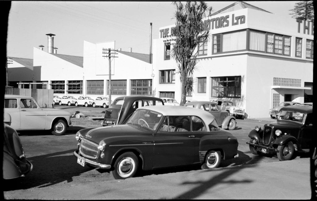
The jewel in Auckland’s crown. Private motor cars parked on Newmarket’s Broadway, 1950s. (Photograph by unknown. Auckland Libraries Heritage Collections 7-A17652.)
Yet high rates of motor vehicle ownership are not inherently problematic. Different cities have different qualities; some can manage high numbers of vehicles just fine. The real problem was that Auckland was becoming incapable of managing its motor vehicles. This was a problem so worrisome that it became a central focus of the city’s 1949 Outline Development Plan (or ODP), a document intended to provide a forecast for Auckland’s future and find ways to combat its oncoming issues. While studying the problem, the ODP outlined two reasons for its emergence.
Firstly, although the number of motor vehicles in Auckland by 1945 was relatively high, by 1949 Aucklanders owned a whopping 200 vehicles per 1,000 people, and such growth in motor vehicle numbers was projected to explode out of control in the future. A series of factors were key to this. One was that Auckland’s population was growing and was projected to spike even more over the following decades, leaving between 425,000 to 475,000 people in the city by 1975. (The existing population in 1949 was estimated at around 300,000 people, so this would be a 50% increase over 25 years.) Alongside this, long-standing wartime fuel rations ceased in 1950. Consequently, operating a motor vehicle became cheaper and more appetising for the average Auckland commuter. The biggest factor, though, was that it was simply becoming more commonplace in Auckland to use cars regularly. The ODP described the motor vehicle as having evolved from a ‘luxury’ and ‘pleasure’ vehicle to a ‘utilitarian’ device by the late 1940s; motor vehicles became a staple of daily life. All of this combined meant that Auckland was expected to be home to more people, each of whom would be more likely to buy cars, which they would likely use more frequently – all at an increasing rate. In other words, the city had to prepare for a rise in motor vehicle traffic that would exceed both the rise in its population, and rise in the number of its vehicles. Looming over Auckland in the decade after World War Two, therefore, was an impending explosion in motor vehicle use far greater than what already existed.
The other part to Auckland’s two-pronged problem was that the city’s transport infrastructure was hopelessly unprepared for any increase in the number of motor vehicles on existing roads. The ODP describes how Auckland’s ‘urban highways’ (today’s inner-city roads) had been constructed in the 19th century to cater for the use of horse-drawn vehicles. From that point onwards little had changed; outer ‘rural highways’ like Great South Road had attracted the most investment. This meant that inner-city roads, like Queen Street or Newmarket’s Broadway, were still relatively narrow and tasked with providing for a multitude of things, including ‘the pedestrian, the shopper, the child, access and service to property as well as intersecting traffics, vehicular parking and all local movement’. Yet despite their narrow lanes and multipurpose uses, these inner-city roads still attracted the most vehicles because they were the only urban routes available. For example, throughout 1949 Broadway carried 20,000 to 24,000 motor vehicles every 24 hours, compared to approximately 5,000 vehicles passing through Great South Road over the same timeframe. The consequence was simple. By 1949 Auckland’s inner-city roads had become, or were slowly becoming, bottlenecks. Little else was to be expected, when Auckland was home to so many motor vehicles, and saw the majority of them pass along the same few stretches of road every single day.
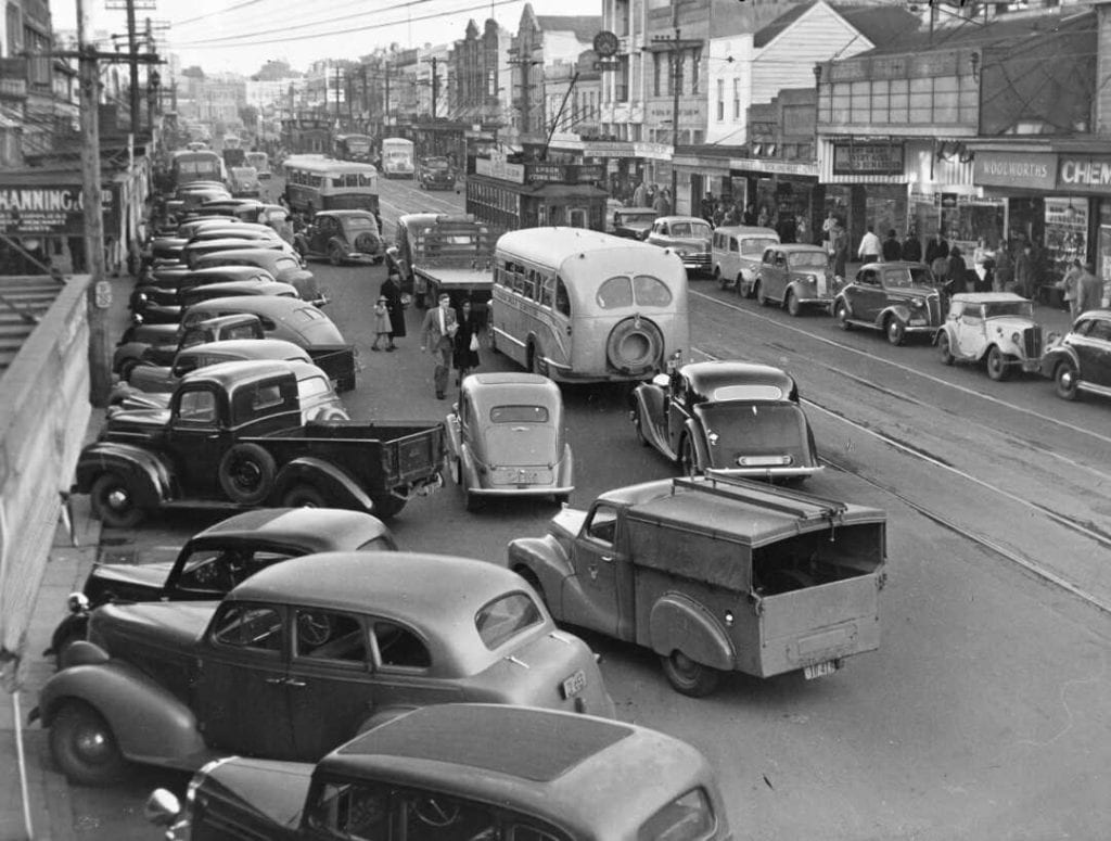
Congestion on Newmarket’s Broadway, circa 1950. This was to become a familiar sight on Auckland’s roads. (Photograph by unidentified photographer. Circa 1950. Reference: PAColl-6303-12. Alexander Turnbull Library, Wellington, New Zealand. http://natlib.govt.nz/records/23137883.)
A combination of these two phenomena provides a telling insight into the scale of Auckland’s late-1940s congestion dilemma. How could the city cope with the projected explosion in motor vehicle use, if almost all of those vehicles would continue to traverse the same ill-prepared routes? What had already proved to be an issue in 1949 was sure to ‘choke [Auckland] into decay’ if it continued. The city desperately needed a solution. It was obvious that this would involve the expansion of Auckland’s transport infrastructure to increase traffic capacity. The contentious part – something which came to dominate transport debates in the city over the following half-decade – concerned the form that that expansion would take. Auckland had two options: to extend its railway system, or to improve its road network. Both proposals would not be constructed together, because they were originally projected to cost five million pounds each. Of course, those hefty price tags meant the national Government would play a significant role in shaping the direction that Auckland would eventually take.
Railways
By the late 1940s, Auckland’s passenger railway system was stagnating. About fifteen years earlier, the central Auckland train station had been shifted from the foot of Queen Street to Beach Road, almost a mile to the east. This forced commuters travelling by heavy rail to and from the city – by far the most important route – to take a tram from the CBD to its train station. This clearly lowered the popularity of rail. Traffic volumes passing through the Beach Road station in 1949 were roughly the same as they had been at the old station in 1931, despite the population booming over that period. On a wider scale, Auckland’s complete rail system carried a miserable 4% of all local traffic in 1949.
Yet despite its sorry state, the Government identified a tantalising opportunity in Auckland’s rail. Existing lines already formed a web across Auckland’s eastern, southeastern and western suburbs; they were let down only by the flawed placement of the Beach Road station and the absence of direct city access. In theory, then, a railway line and stations running straight through the city centre would likely attract many working Aucklanders to the city’s trains. The Government could not help but notice that this had the potential to ease Auckland’s looming congestion problems, and so quickly drafted plans to construct a heavy rail tunnel directly underneath the city centre – a proposal which had actually first been tabled in the 1920s. Then in 1949 the Government sought advice on their plans from Sir William Halcrow and Mr. J. P. Thomas, English engineers who were experts on passenger rail systems. The engineers’ resulting report, strewn across an interim and final version, was (fittingly) entitled the ‘Halcrow-Thomas report’ and eventually became famous in New Zealand transport circles.
The Government’s original request was simple: Halcrow and Thomas were to comment on the viability of their two plans, named ‘Scheme 1’ and ‘Scheme 2’. ‘Scheme 1’ included, among other things, a tunnelled route from Beach Road to new city stations at Victoria Street, Vincent Street and further out at Karangahape Road, before resurfacing at Arch Hill and then continuing on to Morningside. This tunnel was dubbed the ‘Morningside Deviation’. ‘Scheme 2’ dealt instead with the coastal northwest, proposing an underground route from Beach Road to Elliott Street in the city, and then above-ground to Ponsonby, Point Chevalier and (potentially) Kumeu. Both plans also included the complete electrification of Auckland’s rail system. Halcrow and Thomas rejected Scheme 2. However, Scheme 1 was adopted and heavily modified by the engineers into their final proposal.
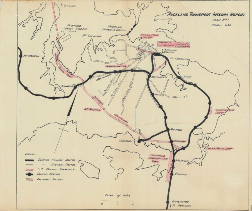
Scheme 1, as proposed by the Railways Department. Proposed lines are in red. Halcrow and Thomas cut out everything except the Morningside Deviation, and then changed the city station locations. (Map No.1 from Halcrow and Thomas’ Interim Report on Auckland Transport, from Auckland Council Archives.)
A close-up view of Map No.1 as shown above.
Yet this was only the face of the Halcrow-Thomas report. The document created more buzz due to its general argument in favour of a railway-based, rather than roads-based, solution to Auckland’s congestion woes. For our purposes, this is the more interesting aspect of the report.
Why rail?
According to the report, Auckland’s predicament was easily explained. More and more Aucklanders were buying cars and driving them into the city centre. This created congestion. The solution, then, was to stop these cars from travelling into the city centre as much as possible.
In the view of Halcrow and Thomas, a rail-based solution could achieve this more effectively than improved roads, because rail offered Auckland an alternative transport artery, or a ‘second plane’ of traffic. If an appealing railway route linked suburbia to the city centre, then many city workers living in the suburbs could use the railway every day and leave their vehicles behind. This would, in theory, alleviate road congestion. By contrast, the report considered the widening of roads and the construction of city centre car parks – some of the proposals endorsed by the aforementioned Outline Development Plan – to be ill-advised ways of relieving congestion. Road widening was deemed a ‘palliative’ or temporary measure, as the projected increase in motor vehicle traffic would quickly devour all the extra space created and take the city back to square one. By contrast, the Morningside Deviation was dubbed a more logical investment because it would increase the railways’ annual capacity to 200 million passengers – a figure Auckland would take a long time to reach. Similarly, providing more parking space in the city centre was considered a congestion stimulant rather than reliever, because the possibility of finding a park would encourage Aucklanders to drive into the city. This would only create ‘confusion in the streets’, as motorists would roam the city looking for empty spaces.
Crucial to the report’s logic, though, was that this railway had to be appealing to Aucklanders. Without an attractive service, Aucklanders would almost certainly remain loyal to their cars. This motivated the choice of route: the Morningside Deviation would include two central city stations that would deliver workers straight to their city workplaces, resolving the inconvenience and unattractiveness of the Beach Road station. It also motivated the choice of rail itself: trains avoided traffic created by pedestrians and other vehicles, and stopped less frequently, ensuring quicker commute times.
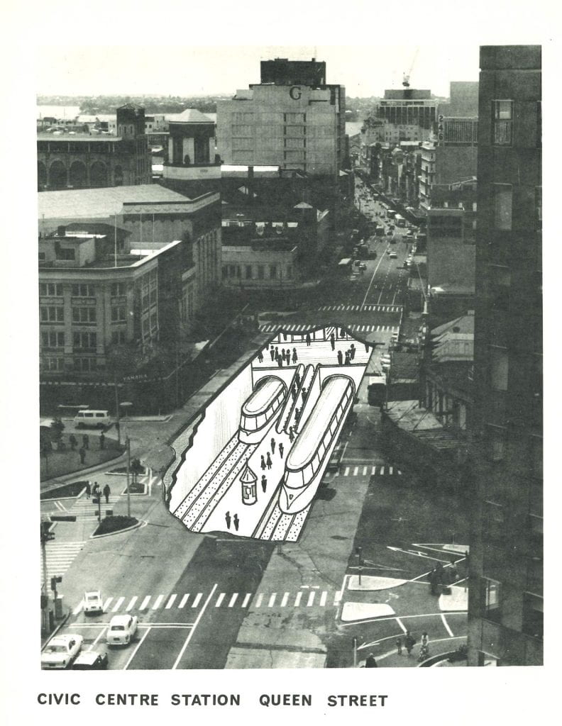
Impressions of a train station near present-day Aotea Square, 1967. The ‘Civic Square’ station proposed by Halcrow and Thomas would have been very similar. (Auckland Regional Authority. Facts about The Public Passenger Transport System in Auckland. Image from Auckland Libraries Heritage Collections.)
Yet the engineers wanted more: they insisted on the electrification of the entire rail system. Electrified trains would not only increase commute speed further to a projected maximum of 60 mph (almost 100 km/h), but also eradicate smoke and reduce noise, making train rides more palatable. Additionally, this would render areas near train stations more tolerable to live in, encouraging suburban development in rings around those stations and driving traffic from those areas straight back to the nearby trains. Most interesting of all was the importance of aesthetics. Suburban railway stations should be bright and stylish, demanded Halcrow and Thomas, so that they would appeal to the average commuter and increase railway patronage.
However, one serious question lingered. Aucklanders had invested a lot of money into their vehicles – would they really abandon them so easily? One idea that Halcrow and Thomas proposed to incorporate motor vehicle use into their plan was the construction of parking lots at larger suburban railway stations. This would solve two problems at once. Firstly, the scheme would give motorists an alternative to driving to and parking in the city, a congestion-producing practice. Secondly, commuters living far from the closest railway station would be able to justify driving there, as they would be able to find a place to park. London was the model for this: according to Halcrow and Thomas it was common for urban workers there to leave motorcars in suburban railway parking lots, and then take the train into the city. To sweeten the deal, the report devised a ticketing system whereby a train ticket would also double as a parking ticket, a bus ticket and a tram ticket. This way private motorists would be motivated to ditch their cars and use public transport in the city as much as they wanted.
In fact, the provision of support to other parts of Auckland’s public transport network was the final benefit attributed to a rail-based solution to Auckland’s congestion issues, rather than a roads-based approach. In their report, Halcrow and Thomas argued that an overall authority responsible for co-ordinating Auckland’s public transport services should be established (in a similar vein to our present-day Auckland Transport). That way, tram, trolleybus and motor bus routes could all be changed to serve Auckland’s train stations. This would give commuters situated far away from these stations an alternative to driving their cars there. Of course, using any public transport – even if sharing the same congested roads as cars while doing so – is always a congestion-alleviating endeavour. The 1939 Auckland Transport Board annual report said as much, claiming that the average motor car passenger took up four times the area and five times the length of roadway of the average tram passenger at peak periods. Thus, a rail-based solution would not just alleviate Auckland’s congestion directly, but also help other public transport achieve the same result.
The results
These conclusions led to two outcomes. The first was obvious: the Halcrow-Thomas report endorsed the electrification of Auckland’s railways and the construction of the Morningside Deviation.
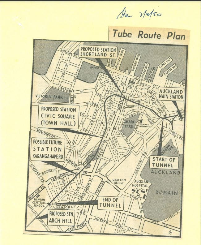
Halcrow and Thomas eventually proposed this form of the Morningside Deviation. Scheme 1’s city stations were moved to Shortland Street and Civic Square, and its Karangahape Road station was deferred. This route is strikingly similar to today’s City Rail Link path. (Map taken from the Auckland Star, October 3, 1950. Auckland Council Archives, The Halcrow-Thomas Report on Auckland’s Transport Problems: Correspondence etc., Relating Thereto, 1950, ACC 275, Box 346, Item 50/299a.)
The second, though, was more striking. The engineers insisted that Auckland refrain from spending on ‘arterial streets’ until the railway was constructed, and its effect could be observed. To them, Auckland would ‘gain more’ from their railway proposal in comparison to a roading scheme. Further, they believed that if the railway scheme proved successful, the city would require fewer roading upgrades anyway.
Yet the Halcrow-Thomas report did not become the defining word on Auckland’s transport system, even if the text itself oozed an air of finality. It is true that the Government openly welcomed the report and investigated its findings over the following couple of years. However, this failed to mask the growth of opposition to the report’s findings that amassed over the first half of the 1950s. It was this opposition – largely influenced by a growing number of Auckland councillors – that eventually turned the situation on its head and led to Auckland’s endorsement of a motorway-based solution to the city’s transport woes. The next article will cover these developments.